
فَیِل:Koppen-Geiger Map ARG present.svg

Size of this PNG preview of this SVG file: 512 × 423 پِکسَل. باقی ریزولوشَن: 291 × 240 پِکسَل | 581 × 480 پِکسَل | 930 × 768 پِکسَل | 1٬240 × 1٬024 پِکسَل | 2٬479 × 2٬048 پِکسَل
اَصلی فَیِل (SVG file, nominally 512 × 423 pixels, file size: 1٫21 میگا بایِٹ)
خُلاصہٕ
| تَفصیٖل |
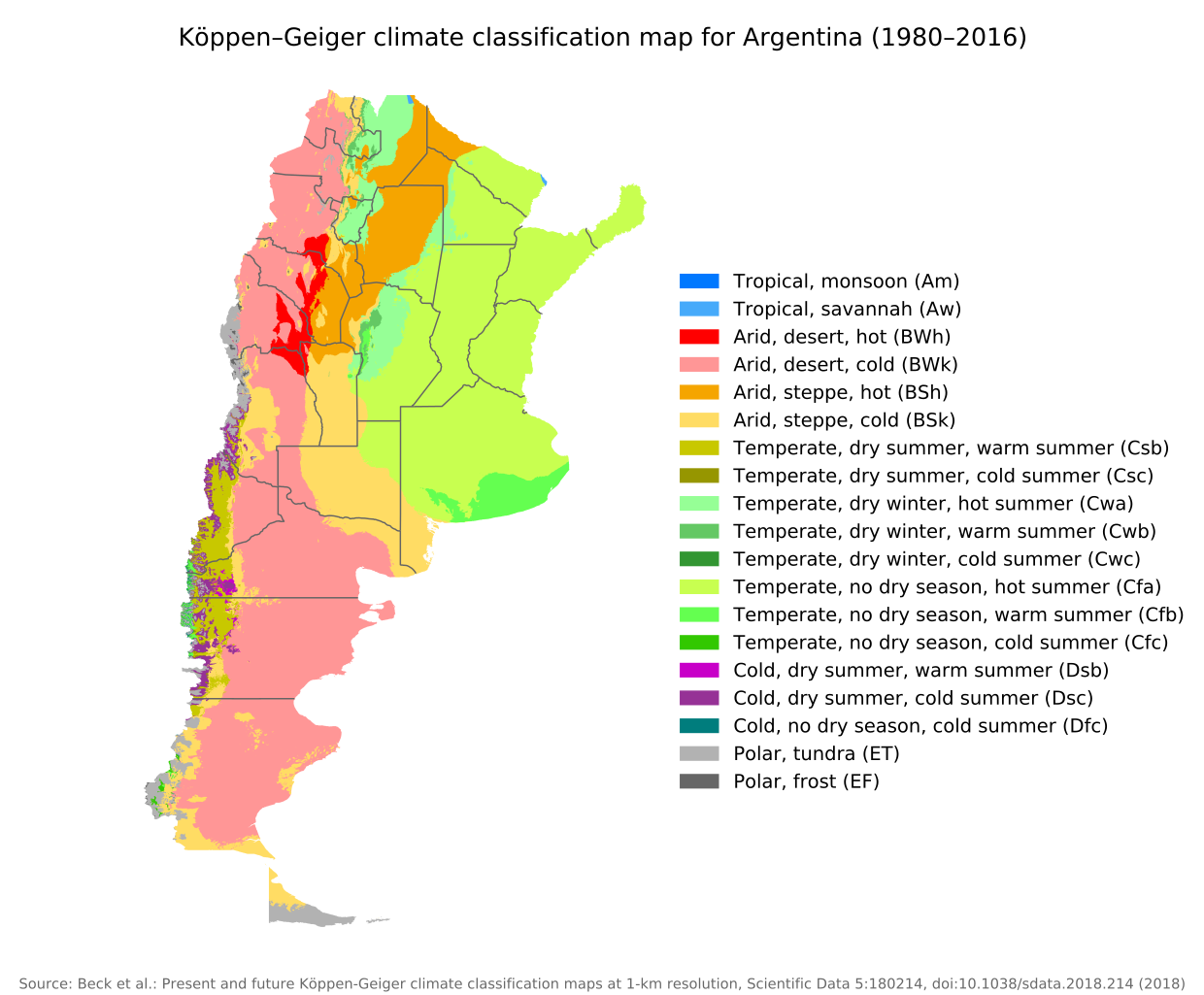
English: Köppen–Geiger climate classification map for Argentina |
| تٲریٖخ | |
| آگُر | "Present and future Köppen-Geiger climate classification maps at 1-km resolution". Nature Scientific Data. DOI:10.1038/sdata.2018.214. |
| مُصَنِف | Beck, H.E., Zimmermann, N. E., McVicar, T. R., Vergopolan, N., Berg, A., & Wood, E. F. |
اِجازَت نامہ:
This file is licensed under the Creative Commons Attribution 4.0 International license.
- تُہۍ چھِو آزار:
- بٲغراوُن – کٲم نَقٕل، تَقسیٖم تہٕ مُنتَقٕل کَرنہٕ خٲطرٕ
- رِمِکس کَرُن – to adapt the work
- یِمَن شَرطَن تَحَت:
- اِنٛتِساب – You must give appropriate credit, provide a link to the license, and indicate if changes were made. You may do so in any reasonable manner, but not in any way that suggests the licensor endorses you or your use.
| Camera location | | View this and other nearby images on: OpenStreetMap |
|---|
فَیِل تَوٲریٖخ
فَیِل وُچھنہٕ باپتھ کٔریو کلک تأریخ/وقت پؠٹھ تاکہِ یہ گژھِ تمہ وقتہٕ ظٲہر
| تٲریٖخ/وَقت | تھمب نیل | پہلوٗو | صٲرِف | کَتھ | |
|---|---|---|---|---|---|
| موجودٕ | 09:14, 8 سَتَمبَر 2020 | | 512 × 423 (1٫21 میگا بایِٹ) | Allice Hunter | Provinces and adjustments |
| 15:44, 17 جُلَے 2020 |  | 1٬208 × 850 (1٫51 میگا بایِٹ) | JPLema | Reverted to version as of 21:36, 15 June 2020 (UTC) | |
| 15:43, 17 جُلَے 2020 |  | 840 × 812 (1٫45 میگا بایِٹ) | JPLema | reducción de tamaño | |
| 21:36, 15 جوٗن 2020 |  | 1٬208 × 850 (1٫51 میگا بایِٹ) | JPLema | Reverted to version as of 03:03, 26 November 2018 (UTC) | |
| 13:02, 15 جوٗن 2020 |  | 696 × 1٬006 (1٫34 میگا بایِٹ) | JPLema | reduje el ancho y aumenté la altura | |
| 03:03, 26 نَوَمبَر 2018 |  | 1٬208 × 850 (1٫51 میگا بایِٹ) | NVergopolan | {{Information |Description={{en| Köppen–Geiger climate classification map for Argentina}}|date=2018-11-06|source={{cite journal | journal=Nature Scientific Data |doi=10.1038/sdata.2018.214}}|author=Beck, H.E., Zimmermann, N. E., McVicar, T. R., Vergopolan, N., Berg, A., & Wood, E. F.|permission=|other_versions=|other_fields=}}{{Cc-by-4.0}}{{Location|-38.42003918|-63.58480835}}Category:Köppen-Geiger Climate Classification MapsCategory:present climate (1980–2016)Category:Argentina[[... |
فَیِلٕ ہُند اِستِعمال
There are no pages that use this file.
فَیِلہٕ ہُنٛد عالمِی اِستِمال
دِنہٕ آمٕتیٚو باقٕی وِکیٖیَن منٛز چھےٚ یہِ بٕہی استعمال سپدان:
- bg.wikipedia.org پؠٹھ استعمال
- ckb.wikipedia.org پؠٹھ استعمال
- en.wikipedia.org پؠٹھ استعمال
- id.wikipedia.org پؠٹھ استعمال
- ja.wikipedia.org پؠٹھ استعمال
- km.wikipedia.org پؠٹھ استعمال
- pt.wikipedia.org پؠٹھ استعمال
- ru.wikipedia.org پؠٹھ استعمال
- sr.wikipedia.org پؠٹھ استعمال
- tr.wikipedia.org پؠٹھ استعمال
- uk.wikipedia.org پؠٹھ استعمال