
فَیِل:Bangladesh divisions english.png
نُمٲشِہ ہُنٛد ناپ: 439 × 599 پِکسَل باقی ریزولوشَن: 176 × 240 پِکسَل | 500 × 682 پِکسَل
اَصلی فَیِل (500 × 682 پِکسَل، فَیِل ناپ: 19 کِلوبایِٹ، MIME قسٕم:image/png)
خُلاصہٕ
| تَفصیٖل |
Español: Divisiones de Bangladesh
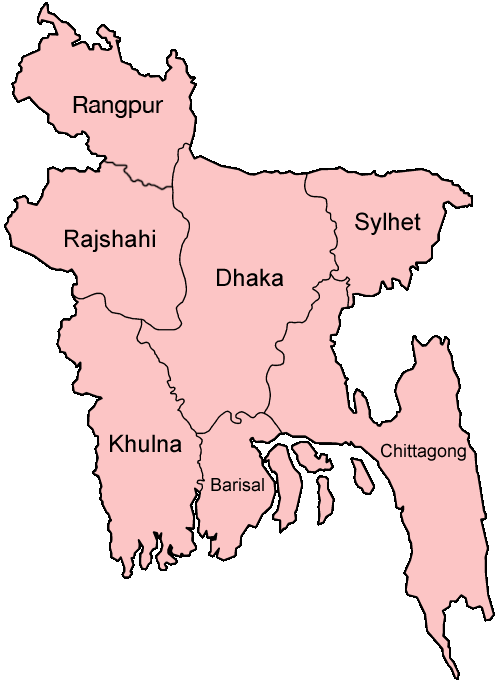
Map of the divisions of Bangladesh in English. Made by User:Golbez. |
| تٲریٖخ | ٣١ دَسَمبَر ٢٠٠٥ (original upload date) |
| آگُر | No machine-readable source provided. Own work assumed (based on copyright claims). |
| مُصَنِف | No machine-readable author provided. Golbez assumed (based on copyright claims). |
derivative works
Derivative works of this file: Bangladesh location map-Rangpur Division.svg
اِجازَت نامہ:
I, the copyright holder of this work, hereby publish it under the following licenses:

|
Permission is granted to copy, distribute and/or modify this document under the terms of the GNU Free Documentation License, Version 1.2 or any later version published by the Free Software Foundation; with no Invariant Sections, no Front-Cover Texts, and no Back-Cover Texts. A copy of the license is included in the section entitled GNU Free Documentation License. |
| یَمہِ فَیِلہِ ہٕنٛز لاسَن چھِ Creative Commons Attribution-Share Alike 3.0 Unported تَحَت یِوان۔ | ||
| ||
| This licensing tag was added to this file as part of the GFDL licensing update. |
This file is licensed under the Creative Commons Attribution 2.5 Generic license.
- تُہۍ چھِو آزار:
- بٲغراوُن – کٲم نَقٕل، تَقسیٖم تہٕ مُنتَقٕل کَرنہٕ خٲطرٕ
- رِمِکس کَرُن – to adapt the work
- یِمَن شَرطَن تَحَت:
- اِنٛتِساب – You must give appropriate credit, provide a link to the license, and indicate if changes were made. You may do so in any reasonable manner, but not in any way that suggests the licensor endorses you or your use.
You may select the license of your choice.
فَیِل تَوٲریٖخ
فَیِل وُچھنہٕ باپتھ کٔریو کلک تأریخ/وقت پؠٹھ تاکہِ یہ گژھِ تمہ وقتہٕ ظٲہر
| تٲریٖخ/وَقت | تھمب نیل | پہلوٗو | صٲرِف | کَتھ | |
|---|---|---|---|---|---|
| موجودٕ | 19:40, 27 جَنؤری 2010 | | 500 × 682 (19 کِلوبایِٹ) | NordNordWest | update Rangpur |
| 00:28, 1 مارٕچ 2009 |  | 500 × 682 (19 کِلوبایِٹ) | Mahahahaneapneap | Compressed | |
| 02:52, 31 دَسَمبَر 2005 |  | 500 × 682 (20 کِلوبایِٹ) | Golbez | Map of the divisions of Bangladesh in English. Made by User:Golbez. Category:Maps of Bangladesh |
فَیِلٕ ہُند اِستِعمال
There are no pages that use this file.
فَیِلہٕ ہُنٛد عالمِی اِستِمال
دِنہٕ آمٕتیٚو باقٕی وِکیٖیَن منٛز چھےٚ یہِ بٕہی استعمال سپدان:
- ar.wikipedia.org پؠٹھ استعمال
- ast.wikipedia.org پؠٹھ استعمال
- ca.wikipedia.org پؠٹھ استعمال
- de.wikipedia.org پؠٹھ استعمال
- en.wikipedia.org پؠٹھ استعمال
- Wikipedia:WikiProject Bangladesh
- Wikipedia:WikiProject Bangladesh/History Workgroup
- User:Jonny-mt/Gallery of current first-level administrative country subdivisions maps
- Wikipedia:WikiProject Bangladesh/Geography Workgroup
- Talk:Bangladesh/Archive 3
- Wikipedia:WikiProject Bangladesh/ResourcesBangladesh
- Wikipedia:Graphics Lab/Map workshop/Archive/Aug 2010
- eo.wikipedia.org پؠٹھ استعمال
- fi.wikipedia.org پؠٹھ استعمال
- fr.wikipedia.org پؠٹھ استعمال
- gl.wikipedia.org پؠٹھ استعمال
- hi.wikipedia.org پؠٹھ استعمال
- बांग्लादेश
- सिलहट विभाग
- चट्टग्राम विभाग
- ढाका जिला
- ढाका विभाग
- राजशाही विभाग
- खुलना विभाग
- बरिशाल विभाग
- नरसिंगडी जिला
- मानिकगंज जिला
- मुंशीगंज जिला
- नारायनगंज जिला
- मैमनसिंह जिला
- शेरपुर जिला
- जमालपुर जिला
- नेत्रोकोना जिला
- गाजीपुर जिला (बांग्लादेश)
- किशोरगंज जिला
- टंगाइल जिला
- फरीदपुर जिला
- मदारीपुर जिला
- शरियतपुर जिला
- राजबाड़ी जिला
- बगेरहाट जिला
- चौडांगा जिला
- येशोर जिला
- झेनईदह जिला
- खुलना जिला
- कुश्तिया जिला
- मगुरा जिला
- मेहरपुर जिला
View more global usage of this file.