
فَیِل:Detailed SVG map of the Anglophone world.svg

Size of this PNG preview of this SVG file: 800 × 411 پِکسَل. باقی ریزولوشَن: 320 × 164 پِکسَل | 640 × 329 پِکسَل | 1٬024 × 526 پِکسَل | 1٬280 × 657 پِکسَل | 2٬560 × 1٬314 پِکسَل
اَصلی فَیِل (SVG file, nominally 2٬560 × 1٬314 pixels, file size: 1٫38 میگا بایِٹ)
خُلاصہٕ
| تَفصیٖل |
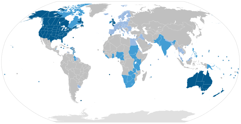
English: Majority native language
Co-official and majority native language
Official but minority native language
Secondary language: spoken as a second language by more than 20% of the population, de facto working language of government, language of instruction in education, etc. |
| تٲریٖخ | |
| آگُر | Speaker figures based on Ethnologue and other sources. Blank map: File:BlankMap-World6-Subdivisions.svg |
| مُصَنِف | Jpthefish |
اِجازَت نامہ:
I, the copyright holder of this work, hereby publish it under the following license:
This file is licensed under the Creative Commons Attribution-Share Alike 4.0 International license.
- تُہۍ چھِو آزار:
- بٲغراوُن – کٲم نَقٕل، تَقسیٖم تہٕ مُنتَقٕل کَرنہٕ خٲطرٕ
- رِمِکس کَرُن – to adapt the work
- یِمَن شَرطَن تَحَت:
- اِنٛتِساب – You must give appropriate credit, provide a link to the license, and indicate if changes were made. You may do so in any reasonable manner, but not in any way that suggests the licensor endorses you or your use.
- یَکساں-شَرکٔر – If you remix, transform, or build upon the material, you must distribute your contributions under the same or compatible license as the original.
فَیِل تَوٲریٖخ
فَیِل وُچھنہٕ باپتھ کٔریو کلک تأریخ/وقت پؠٹھ تاکہِ یہ گژھِ تمہ وقتہٕ ظٲہر
| تٲریٖخ/وَقت | تھمب نیل | پہلوٗو | صٲرِف | کَتھ | |
|---|---|---|---|---|---|
| موجودٕ | 09:51, 26 اَگَست 2023 | | 2٬560 × 1٬314 (1٫38 میگا بایِٹ) | Kwamikagami | rv: you just removed light blue, which we use on other maps |
| 01:35, 26 اَگَست 2023 |  | 2٬560 × 1٬314 (1٫36 میگا بایِٹ) | Jpthefish | Reverted to version as of 01:23, 3 July 2020 (UTC) Forgive me if I am mistaken, but I have not seen sources to corroborate the light blue coloring of the EU, SE Asia, or other regions. The light blue color in my other maps was previously reserved for lanauges with cultural or secondary status - that is, a historically significant language and/or a language spoken by over 20% of the native population. I am open to changes though, as long as they are consistent across all SVG maps and reflect a... | |
| 05:42, 9 اَگَست 2023 |  | 2٬560 × 1٬314 (1٫38 میگا بایِٹ) | Kwamikagami | some countries marked as majority English were majority creole | |
| 06:33, 15 جَنؤری 2023 |  | 2٬560 × 1٬314 (1٫38 میگا بایِٹ) | Kwamikagami | clean up Quebec; Faroes assumed | |
| 05:50, 15 جَنؤری 2023 |  | 2٬560 × 1٬314 (1٫38 میگا بایِٹ) | Kwamikagami | 2nd language >20%, & de facto govt working language, per Ethnologue. | |
| 01:23, 3 جُلَے 2020 |  | 2٬560 × 1٬314 (1٫36 میگا بایِٹ) | Jpthefish | New section | |
| 22:47, 8 جوٗن 2020 |  | 2٬560 × 1٬314 (1٫36 میگا بایِٹ) | Jpthefish | Lighter secondary colors | |
| 17:17, 25 مٔیی 2020 |  | 2٬560 × 1٬314 (1٫36 میگا بایِٹ) | Jpthefish | edit Channel Islands | |
| 18:19, 8 مٔیی 2020 |  | 2٬560 × 1٬314 (1٫36 میگا بایِٹ) | Jpthefish | Add Cameroon | |
| 02:15, 8 مٔیی 2020 |  | 2٬560 × 1٬314 (1٫36 میگا بایِٹ) | Jpthefish | Uploaded own work with UploadWizard |
فَیِلٕ ہُند اِستِعمال
یہِ صَفہٕ چھُ اَتھ فَیِلہِ اِستِمال کَران:
فَیِلہٕ ہُنٛد عالمِی اِستِمال
دِنہٕ آمٕتیٚو باقٕی وِکیٖیَن منٛز چھےٚ یہِ بٕہی استعمال سپدان:
- af.wikipedia.org پؠٹھ استعمال
- ang.wikipedia.org پؠٹھ استعمال
- ar.wikipedia.org پؠٹھ استعمال
- ast.wikipedia.org پؠٹھ استعمال
- av.wikipedia.org پؠٹھ استعمال
- az.wikipedia.org پؠٹھ استعمال
- ba.wikipedia.org پؠٹھ استعمال
- be.wikipedia.org پؠٹھ استعمال
- bg.wikipedia.org پؠٹھ استعمال
- bn.wikipedia.org پؠٹھ استعمال
- br.wikipedia.org پؠٹھ استعمال
- cv.wikipedia.org پؠٹھ استعمال
- en.wikipedia.org پؠٹھ استعمال
- en.wikibooks.org پؠٹھ استعمال
- es.wikipedia.org پؠٹھ استعمال
- fa.wikipedia.org پؠٹھ استعمال
- fr.wikipedia.org پؠٹھ استعمال
- ga.wikipedia.org پؠٹھ استعمال
- guc.wikipedia.org پؠٹھ استعمال
- he.wikipedia.org پؠٹھ استعمال
- hr.wikipedia.org پؠٹھ استعمال
- hy.wikipedia.org پؠٹھ استعمال
- id.wikipedia.org پؠٹھ استعمال
- incubator.wikimedia.org پؠٹھ استعمال
- it.wikipedia.org پؠٹھ استعمال
View more global usage of this file.